The 20th stage of the Trans-Pyrenees Crossing takes you to the Àneu Valley, the third of the great valleys of Pallars that you have the opportunity of crossing, after Ferrera Valley and Cardós Valley. The start of the day is Mont Caubo, also known as Lo Calbo, a mountain that separates the Vallat d'Estaon from the Àneu Valley, offering you superb views in all directions thanks to its intensely isolated location. The stage is physically demanding and requires being alert to the directions since signage in some stretches is scarce.
Considerable. Derived from the length and ascent to overcome. This stage does not have any technical difficulties.
In winter you can find snow on the mountain pass of Clot de la Calba.
No special equipment required.
High Pyrenees Nature Reserve. 01:50.000. Editorial Alpina.
Topographic base of Catalonia 1:25.000. Geological and Cartographic Institute of Catalonia (ICGC).
Let's begin the 20th stage of the Trans-Pyrenees Crossing to (1) Estaon (0:00 - 1,255m). During the first part of the route you will have to overcome almost 1000m of climbing to reach the mountain pass of Clot de la Calba. Depart from the top of the village, heading N. You will advance on a cobbled path that climbs the eastern side of the Solà d'Estaon Mountains. Go around this mountain and you will slowly turn to the left (NW). You will soon reach the Palau Cabin, the point where you will cross the Fertero Ravine. You will reach a (2) fork to the left (0:50 - 1,516m). Leave the trail that continues straight ahead towards Pau Cabin and take the path that climbs to the left (W) by means of a rounded ridge.
Go up this path, which alternates open spaces, meadows and some interior forest stretches. The climb is long and demanding. You will finally reach the (3) mountain pass of Clot de la Calba (2:15 - 2,221m). Just to the right (N) you have the peak of Mont Caubo and Lo Calbo (2,281m), with its characteristic antennas on top. We highly recommend detouring for a moment and climbing to the top. Despite not being too high, the isolated location results in this mountain being a wonderful vantage point from all its surroundings.
From the mountain pass you will begin the descent to Guingueta d'Àneu by means of a path that goes around the summit of Mont Caubo on its western side. You will cross the ridge that joins the peak with Guilar Hill and enters a lush forest by means of the shady side of the mountain. After walking some 2 km through the interior of the forest you will be back on the sunny side. You will see the small town of Dorve just below you. The path winds down and you will reach (4) Dorve (3:30 - 1,395m), a town that is almost deserted.
From Dorve you only need hike the last stretch descending to Guingueta. The path descends towards the SW and around Dorve Mountain. To your right you have the Torrassa Reservoir. Hike the last stretch on a paved path and you will reach (5) Guingueta d'Àneu (4:15 - 941m).
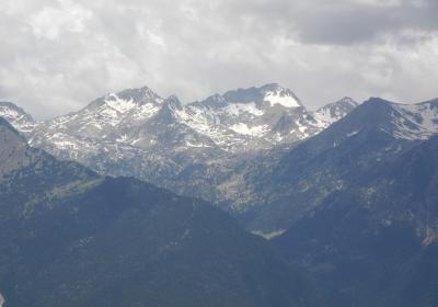
The magnificent views that you will have in all directions from the mountain pass of Clot de la Calba or from nearby Mont Caubo.
Walking through the lonely and mysterious village of Dorve.
The approach to Guingueta d'Àneu along the side ofTorrassa Reservoir.
According to the legend, in Guingueta d'Àneu you can find the hammer of the hero Roland? Again, as in Maçanet de Cabrenys, we run into the legend of the Carolingian hero. According to one of them, Roland, after opening the famous divide, threw his mallet or hammer very far and it fell in Guingueta.
Walking around the reservoir of Torrassa. This reservoir is located between the municipalities of Guingueta d'Àneu and Espot and is surrounded by several paths that are ideal for a stroll. Fishing is one of the main activities of the area and the trout of the Noguera Pallaresa River are greatly appreciated. If you have the opportunity, we recommend trying some trout at one of the establishments in the area.
Throughout the entire stage of the GR 11 the signage is scarce and in some places the roads are not very well defined. For this reason you must pay close attention to your direction.


